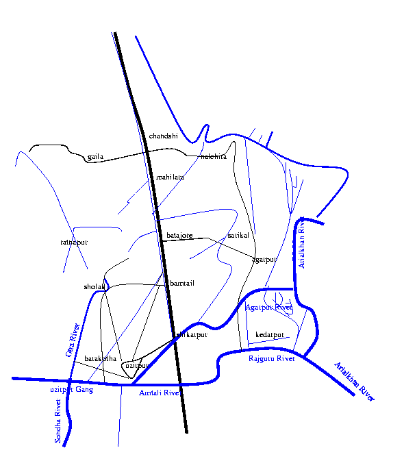
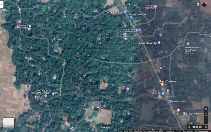
moD.AkATh_I (মোড়াকাঠি) names two villages which are mouzas (North (উত্তর) and South (দক্ষিণ)) in the Bamrail union of the Uzirpur (উজিরপুর) upazila (used to be thAnA; North Morakathi is near the border with Gaurnadi upazila) of the barisAla (বরিশাল) district of the barisAla (বরিশাল) division in present day bAGglAdesha (বাংলাদেশ) It is close to the highway N8 Bhanga-Barisal (ভাঙ্গা বরিশাল) Highway from barisAla sadar, and on the bank of a small stream. A freehand sketch map of the region (and a satellite picture; the map is not very accurate) is shown below. Our village is on both sides of the road going from Bamrail to Sholak (close to Bamrail; 22° 53' 20" N 90° 15' 10"E) as shown in the satellite picture; click the picture for a Google map view
A freehand map (not very accurate) of the region around Morakathi; and a google map view focusing on Uttar Murakati. Dakshin Murakati is South/Southeast of this.
Thanks to Norbert G. Mendes for providing the following information: To get to moD.AkAThI, get to petrApol in India and cross over to benApol in baaGglAdesha. A bus to barisAla is available: get off at shikArapura, and walk a couple of miles to get to the village. From Dhaka, the easiest way is to get to barisAla by air and take the bus, or take the bus to barisAla and get off at shikAra-pura, or take the launch to shikArapura.
What information I had is the following:
You can follow along my guesses of the two poaible riverways in the following paragraphs approximately at the Google maps walking directions and alternate walking directions. According to it, the distance from Khulna to Jhalokathi is about 150–170km and Jhalokathi to Bamrail is about 35km. The bus route from Khulna to Barisal mentioned above probably goes through Madaripur instead.
Even fifty years back (i.e. just before independence), the easiest way to go to this place from Calcutta involved taking a train to khulnA Station (22°50'33"N 89°33'30"E), which took the better part of a day, and then by an overnight steamer ride down the river to jhAlokAThI (22°38'30"N 90°12'17"E). I am not sure the path it took: on the map today it looks like there may be two waterways: the more likely southern one (which is still used part of the way by paddle steamers, the Khulna end being too shallow for them now) is longer but goes along larger streams. It starts by going south downstream along Rupsha river, whose lower reaches are called the Pashur river, to Mongla and then taking Mongla river east to Khasiyakhali river (from where the Dharatana river goes to Bagerhat); then taking the Khasiyakhali river, whose lower reaches are called Pangunchi river, past Morrelganj, past Sannasi (where the Sannyasi river takes off) to meet Balaswar river near Boromashua/Mathbaria. Then going North along Balaswar river, near Char Khali, one turns to Katcha river which falls into the junction of Kaliganga and Sandha rivers near Sreeramkathi and Hularhat. For both the northern and southern routes, one then goes upstream along the Sandha river past Doihari and then east along Gabkhan river/canal at Amrajuri near Kaukhali. This branches at Samudoykathi allowing one to go Southeast towards the Bishkhali river just downstream of Jhalokathi. In today's fast steamers, the time from Khulna would be about 1.5 hrs to Mongla, 2.5 hrs to Morelgonj, 5 hrs to Baramasua, 7.5 hrs to Hularhat, 8.5 hrs to Kaukhali, and 9.5 hrs to Jhalokathi. The steamer can then go further, the river becoming Sugandha and Kirtankhola, to Barishal in another 3.5 hrs, and then along Kirtankhola, Dakatia, Meghna, Shitalakha and Buriganga rivers to Dhaka taking another 7 hrs.
From Jhalokathi, one had to take a small boat to bAmarAila through shikarpore (22°51'N 90°16'E; the current road goes over the shikarpore bridge a bit to the southwest) again taking up the daylight hours, and thence to moD.AkAThI on foot. I guess this as using the Barisal canal system straight north along the Jhalakathi canal that starts at Jhalokathi towards Baukathi, past Nabogram, Panchagram, Binoykathi, Madhabpasha, Guthia, falling into Sandha river near Kamalapur Bazar (This branch of Sondha River is called Amtali river in my hand drawn map); and then up Shikarpur river. My father, however, seems to remember Cowkhali on this route, so it is possible that the boat actually went back along the Gabkhan river back to Sandha river and up Sandha river, part of which may have been the Uzirpur Gang. He then remembers taking the Arial Khan river: whereas Shikarpur river seems more likely; may be it was the main stream of Arial Khan river then. Or else the boat did go further up the Sandha river (with the names of Amtali river and Rajguru rivers, may be) and then enter the current Arial Khan river. From their it could have come down the current Shikarpore river. I do not see any waterway from here to Bamrail today, but there is the Agarpur river starting further upstream from Shikarpore terminal, a branch from which starts at Agarpur and goes to Batajor. But since the name Bamrail Bandar still exists near today's Bamrail bus station, most likely there was an old waterway till there, may be directly under the modern highway from Shikarpur. Our house was called shiromaNi bATi after guru-caraNa shiromaNi.
bATAjora and mailArA (mahilara) villages (now unions in gaurnadi upazila of wazirpur upazila) near it are more well known because of ashvini kumAra datta and surendra-nAtha sena, who were born at the two villages respectively.
Our family originally lived in purAn bAD.i (‘old house’), which was a brick house southeast of manasAtalA and rAYabAD.i (I could not locate these on the map today, but there is a manasA mandir in shAkhAD.IpAD.A, which is at 22° 54' N 90° 14' 52" E, in DakshinPaschim pAD.A in Bamrail, probably too far north to be relevant. There is also a reference to a "Banomali Karmokar bari Ma Monosha Mondir" in Google maps at 22° 53' 38.6" N 90° 15' 22.0"E V7G4+XF2, whose address, however, is V7G4+XF2, Village kholna,PO Morakhati PS Uzirpur Dist, Barta, Bangladesh. It is marked as a hotel in the map, and southeast of the region called dakkhin morakathi). The descendants of kAshinAtha continued living in that house, till they moved to Calcutta. Kashinath's brother Shambhunath's family, however, moved to a mud house southeast of this. Within this cluster of mud houses, some descendants of Harinaryan continued living in the eastern building and descendants of his two nephews Gurucharan and vaNamAli lived in the southern and western buildings respectively. Then Nalini moved to a new building further west. The north of the property by the stream was used for toilet and dumping garbage. Harinarayan's son Ambikacharan's descendants, however, moved to naYA bAD.i (‘new house’), a mud house to the southwest across the road.
We had some land far away in bholA. My father does not remember a jamIdar in our village, definitely not a resident or a hindu one. There were a few other brahmin families in the village (one for example maintained the manasA bAD.i). The muslims resident in the village were either in menial jobs or were farmers.
A few years back (i.e. around 2003), my aunt visited the village. Our lands have been taken over, and almost no one remembers the shiromaNi bATi. There is a hindu family in the village still, and their occupation is as a schoolteacher, but the village is now almost totally muslim. (Incidentally, there is a Mukhopadhyaya family living at least since 1975 in Delhi who claim to be originally from Morakathi in Barisal.)
![]()
![]()